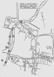
At the six arches…No 1… the river divides;
straight on, through the brick arches, the level of
the water drops by five or six courses of bricks
so, about half a metre, but giving a sharp increase
in speed.
This is the main river which continues in a channel
…No 2; the 1:2500 OS map of 1936 shows it
as 7m wide, the width of the Six Arches, but my
measurement is about 10 metres. It runs straight for
110 metres down to a low weir…No 3. About 15
metres further on there appears to be another low
weir…no 4.
Throughout this stretch, the 7m- 10m channel has
been narrowed to about one third of the more normal
width of the Itchen. Below the downstream weir, the
river widens out to a more natural and irregular
width, with much less evidence of interference.
Back at the top, the river is divided to the left of
the brick arches in a channel of approximately 12
metres width, narrowing to about 10m. This is the
Segars Drain... No 5. It flows at a much
gentler gradient, parallel to the main river and is
retained at a higher level by a bank which divides
it from the main river. Its flow is regulated by
the hatches within the Six Arches. The Drain
continues along the edge of the garden of Elms House
and its neighbours, then past the yard of Segars
farm.…No 6. Here the retaining bank narrows
and the two watercourses are tight up against each
other, but with a one metre difference in level.
In the bank is a hatch from the Drain into the main
river…No 7. Where this discharges into the
lower of the river channels, there is a deep pool,
formed it would seem by a strong flow over a long
period. Segars drain then continues past Segars
Farm…No 8… through the Water meadows …No 9...
of Manor Farm past Twyford Moors House and so
eventually back into the Itchen.
There is, so far, as the reader will have noticed,
no mention yet of a mill, let alone the mill of
South Twyford which Mike and I have boldly
illustrated in the third drawing. However if you
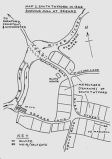
look at map 1 and you will see “ mill” at the bottom
of Segars Lane. Today there is no sign of a mill;
there is no memory of one; no street or place name;
none of the local histories refer to one in this
location.
How to explain all this? Is there an explanation
for the surviving watercourses which can be
reconciled with the known history?
As we have seen in my earlier articles , there were
five or six mills in Twyford in the Domesday Book of
about 1080 . In the Pipe Roll of 1301 (translated
by Mark Page and published by HRO) there are five
mills and all are named. The mill of South Twyford
is one of these.
Where is South Twyford ?
The next step is to locate South Twyford, Here there
is ample evidence which is summarised in the
excellent survey of Twyford in the Winchester
section of “ Historic rural settlements” by Hants
CC in 2004. This suggests that North Twyford is the
original location of the village; that is where the
church has been back to Saxon times and it has its
own mill “the mill of North Twyford” …now Hockley
Mill.
North Twyford Mill is recorded in the 1209 Pipe
Rolls, which suggests that South Twyford is already
a distinct part of the village. Historic Rural
Settlements even suggests a pre Domesday foundation
for South Twyford, and that it was a planned
settlement. My own training as a town planner leads
me to the same conclusion.
The plan of Queen street shows to this day small
tight rectangular plots, which are the classic
“messuages” of the manorial village. Most villages
of this age do not have the same formal
arrangement. One or two of the houses of this part
of Twyford date from the late 1300’s and several
from the 1400’s; many front the street,- again
typical of a village street of that age.
Again it is typical of a manorial village to have
its own mill, provided the water power was
available, so the existence of a Mill of South
Twyford fits in with the normal manorial practice as
well as being confirmed by the 1301 pipe roll.
A location at the bottom of Segars lane makes it
both close and convenient to the people who used ti.
The mill of south Twyford fits snugly into the yard
of Segars farm. So two of the tests for the location
of a mill are met, namely that of access and the
need for it. All this is consistent with Map1 which
suggests the layout of Twyford in 1346; it is
remarkable how close this is to the present day.
Would a mill work in this position?
Two further and basic requirements for a mill
are adequate flow and adequate head of water.
The Itchen at this point gives both. To create
the head, the weir is built at 1; this is
far enough below the ford , 10, so as not
to interfere with its use by creating excessive
depth. Segars drain gives it both an ample
flow. The fall down to river level is about 1
metre. The channel to the left,( the eastern
one) 5,is the mill leat and this
maintains an artificial height for the head
Between the mill leat and the river and shown on
the OS maps is the sluice…No 7. This is
the bypass which allows the mill to be shut off
for repairs and to regulate variations in flow;
the deep pool at its foot is an indication that
it flowed constantly for long period. As Mike’s
drawing of Twyford in 1346 shows, the mill
wheel would then be immediately below this
sluice with its race discharging into the
river. This channel for the mill less easy to
identify but there is a dry, grass channel below
where mill is shown onMap1.
The mill leat would have stopped at this point;
Segars Drain was probably not extended until it
was put to the separate use as a feed for the
Mildmay’s water meadows in the 1700’s.
When was the mill of South Twyford first built?
There is no easy answer to this question. The
mills of Shawford and North Twyford are older ;
both are close to South Twyford and could have
provided the necessary milling for the
villagers. There are however tantalising
references to the building of a new mill in the
Pipe Roll of 1209:
“Expenses of the mill
– in iron bought for making the spindles,
mill-rinds and picks [for dressing mill stones]
for the new mill, and for the Shawford mill, and
the Compton mill, 4s. 3 d. In wages of the smith
12d. In planks bought for making mill buckets,
and for the repair of the wheels of the new
mill, 10d. In wages of the carpenter, for the
same, 3d. For the purchase of one mill-stone for
the aforementioned mill, 21s.” (trans: Charlotte
Bellamy)
When
did the Mill of South Twyford cease to operate?
The lack of any reference to the mill of South
Twyford in the Pipe Roll of 1409/10 (ed Mark
Page: published HRO) suggests that it was a
casualty of the Black Death and that, from then
on, Shawford Mill and the Mill of North Twyford,
were the mills for Twyford Village; however
there are about 250 of the Pipe Rolls which have
yet to be read in the sort of detail which the
1906 translation of the 1209 Roll and Mark
Page’s more recent ones, have made possible. So
it is best not to be too dogmatic.
To sum up, Mike and I have, in this article,
located the mill of South Twyford and made the
first drawing of it and suggested a date for the
mill and the weir and the Segars carrier of 1209
.
We suggest that the channels were constructed
then and have remained in place to this day. Are
we right? The existence of the mill of South
Twyford in the yard of Segars Farm is, I hope,
plausible enough to encourage some one to
explore the ground further.
Note: The name Segar occurs as one of the
tenants of Twyford in the 1209 Roll; it seems
likely that people in those days were named
after the places they lived in; Hockley is a
similar Twyford case. The A/S “sigan” is the
verb “drain”.
For the other articles in the series please
click the button :
The 5 Mills of Twyford: The Unravelling of
Shawford Mill

Twyford’s Historic Landscape:
Mill No 3, The Mill at Compton