The Flow: The Bishops Drain, the Navigation and the
Parish Boundary
Looking at the valley today, the Itchen has enough
water to drive two mills at the same time all year
round. Shawford Mill has abundant water with about
one third of the flow of the river as does Hockley
Mill from the flow of the remaining two thirds.
Compton Mill was far enough upstream from Shawford
Mill to have utilised the flow of the Bishops Drain
without affecting Shawford’s operating potential.
The Itchen’s flow on the Compton side of the valley
is today of course carried for the most part by the
Itchen Navigation. However the Navigation dates only
from about 1710, so we have to figure out the
previous alignment of the main watercourses.
The evidence for this is the boundary between
Compton and Twyford. Parish boundaries had begun
to take shape in middle Saxon times, seem to have
been fairly settled by Domesday and were, according
to Rackham, set in stone by 1180. Mark Page in a
personal communication says that this boundary would
have been set before Domesday i.e. 1086. . See also
Time Team no 167 Dotton Mill..
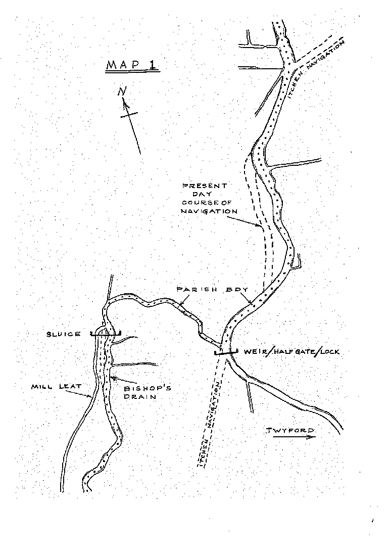
Mike’s Plan shows the parish boundary as on the 1908
OS, before it was changed at the request of Compton
parish in about 1988. It shows the main river
extending south of its present take off at Tumbling
Bay in a broad easy sweep along the line of the
Navigation before the two diverge. This is at a
point where the parish Boundary goes off at right
angles to the River/ Navigation. It follows the line
of a deep irregular ditch. It now carries no flow
and is overgrown but appears little altered. This
is the Bishops Drain, a watercourse built to provide
for the water needs of Compton, owned and managed by
the Bishop
So the Bishops Drain was established as
a significant and permanent feature of the valley
landscape well before 1086. As it is a man made
structure, not the natural river; it depends for its
flow on the artificial raising of the river level.
To understand how it would have been fed in 1300, we
have to airbrush out the Navigation which is
elevated from Tumbling Bay to Compton Lock. Before
1710, the level of the river would have been
significantly lower than today. To provide the
flow into the Bishops Drain required the same sort
of Hatch as at Tumbling Bay today, or a
weir across the river to maintain the flow in the
Drain during the seasonal fluctuations of the
river. Mike’s plan shows this.
The
Parish boundary follows the course of the Bishops
Drain, at first due west until it reaches the very
edge of the flood plain; it then turns southwards
following the western edge of the valley floor, past
Compton Place and down to Shawford Mill. There the
Bishops Drain runs past the mill to re-join the main
river. The alignment of the Parish boundary shows
that the Itchen Navigation incorporated the
existing course of the Bishops Drain for
significant stretches; the parish boundary appears
to have been unaffected by the construction of the
Navigation.
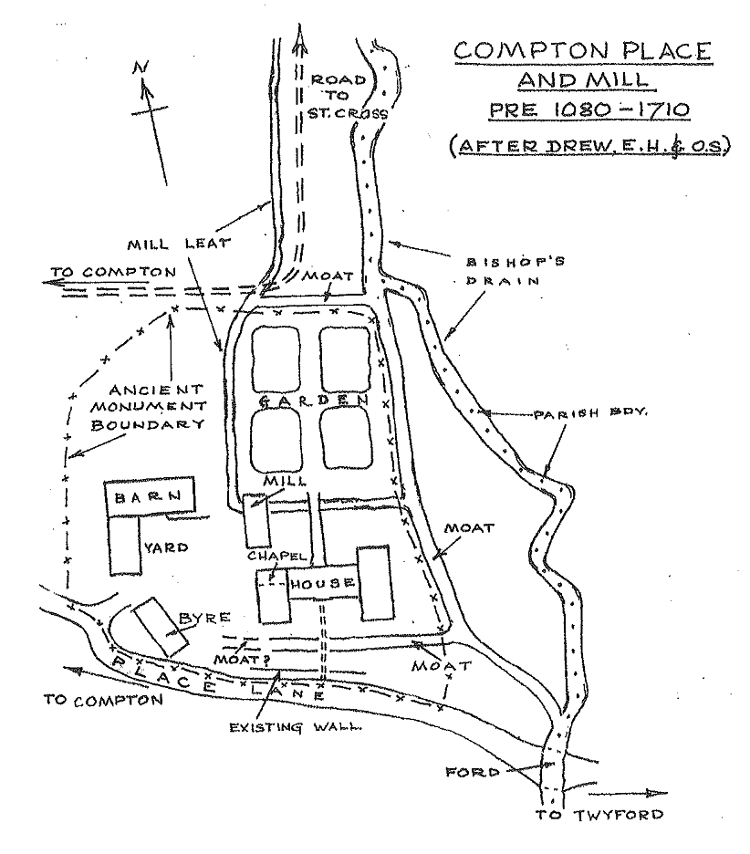
The mill leat
As far as I can see the required fall can only be
obtained if the mill leat was taken off the Bishops
Drain about four hundred yards higher up. There is a
point where the Parish boundary does not follow the
centre line of the Drain, just at the point where a
further hatch would have been required. The flow was
then led along the western edge of the valley;
Mike’s plans show this.
The line of this leat can be seen on the ground at
the northern end. Within the Ancient Monument, there
is evidence of an elevated leat in a direct line.
Significant earthworks survive; there is a deep
depression which could have been the mill race. It
all shows up in the earthworks survey of the County
Museums service as well as on the ground.
The site of the mill of Compton
Mikes drawing shows two possible sites for Compton
Mill but gives prominence to my preferred
location and how it might have related to the
mansion at Compton Place. Mike’s drawing is the
first of this great house ever to have been
attempted and is only one of a number of possible
interpretations of what it might have looked like.
All we know is that it had 14 fireplaces in the
seventeenth century. If the mill was at Site 1,
the surviving Earthworks, if I have interpreted them
correctly, give very little scope for moving the
position of the mill wheel and building. A more
detailed plan could be attempted based on the
available evidence.
Site 2 was preferred by a number of the members of
the Mills Group Committee when they inspected the
site in the winter of 2013 but to my mind the levels
do not work in its favour and it does not explain
the evidence I have put forward in this article. The
matter could easily be resolved by further expert
evaluation and some limited excavation
The Wider Picture
This reconstruction is part of my attempt to
interpret the multiple watercourses still evident in
the valley between Hockley Mill and Place Lane,
Compton. It is fraught with difficulties; Over the
last one thousand years, this part of the valley has
been modified by a series of major engineering
works, all of which have had the potential to affect
the site of Compton Mill or the Mill itself;:
The Bishops drain; the Wascelyn House; the water
meadows of the 16th
to 19th
centuries; the Navigation of 1710; the railway of
1840; the bypass of 1938; tank exercises in 1944;
the M3 and the restoration of the bypass route are
the main ones.
Note: The grid reference for Compton Place is E:
4750 N: 2550
For the other articles in the series please
click the button :
The 5 Mills of Twyford: The Unravelling of
Shawford Mill

The Mill at
South Twyford