This series of articles looks at what can be said
about the Mills of Twyford before the current
buildings were constructed. In the last issue I
wrote about Hockley Mill and showed that the
present position of the mill and its leats changed
radically around 1800 and that the former mill was
to the north and fed directly off the river. The
current Shawford Mill was built only a few years
before Hockley but as “The Mills of Hampshire” says,
it may date back to Domesday. So this article
explores that statement.
Trying to figure out what Shawford Mill looked like
in the past 1300 years is a like peeling an onion;
several layers have to be removed before you see
what you are looking for. With the onion, you start
on the outside; with Shawford Mill we start with the
present day. Today’s mill sits in a complex and
heavily engineered landscape, roads and bridges to
the front, the Itchen Navigation and towpath to side
and rear, the leats and the mill stream around and
underneath. The levels are all over the place.
Beyond are the massive railway embankments and
cuttings. The mill faces a landscaped park and
water meadows. Almost all postdate 1685 when the
Mildmays started their building of Shawford Park and
moved from the Manor House. The mill itself was
built in 1785; none of the buildings you see as you
walk along the Shawford Road or the Navigation
footpath is older than this.
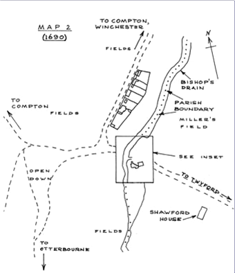
Clue 1: The Parish Boundary.
The Parish Boundary between Compton and Twyford was
changed in the 1990’s but before that the western
limit of Twyford followed water channels; the
boundary is clearly defined on the 1: 2500 OS maps
of the 1908 series: see Plan 1
(page 18).
Oliver Rackham says in his History of the
Countryside that parish boundaries were set in stone
by 1280 and Dr Mark Page suggests that the
existence of Twyford Parish in the Domesday Book is
proof enough that the 1908 Parish boundary was the
parish boundary in 1086, (personal communication)
(see Note 1 below)
(Note 1) The parish boundary was amended on the
initiative of Compton and Shawford Parish Council by
Ordnance Survey in the mid 1990’s. It moved the
boundary from the Bishops Drain (note 2), north of
Compton place lock, eastwards to follow the centre
line of the Navigation.
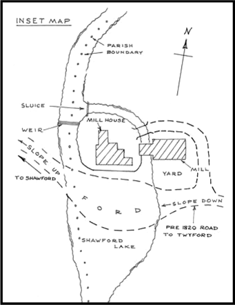
Clue 2: The Channels
Let us look at this boundary a bit more closely.
From south of Compton Lock, it follows the line of
the Itchen Navigation to a point just down stream of
the present Mill leat. It then cuts across the
towpath (which is on a raised bank) and then resumes
the centre line of the drain to the point about 600m
downstream, where it re-joins the main river (not
the Navigation). As we know, the Navigation was
opened only in about 1710. For the 600 year period
back to Domesday and before, what was the water
supply that powered Shawford Mill and how did it get
to the mill? The simplest explanation is that the
new Navigation simply widened the existing channel
which fed the Mill and modified the leats and
hatches to maintain the drive to the mill.
What then is the evidence for the take-off point for
the Mill feed being moved for the Navigation?
Firstly, the line of the parish boundary as shown on
the 1908 map. It does a curious little indent,
unrelated to the present channel, but immediately
explained if the Mill take off was at this point.
Secondly the new take off forms a dock for unloading
goods bought by canal from Southampton to Twyford.
Coal, stone, culm are listed on the new milepost by
Shawford Mill cottage; perhaps cattle and sheep were
sent back downstream, and hay, straw and flour for
the markets in Southampton. I have heard that this
was called Coal Wharf. Between Mill Cottage and the
Mill, there is ample space for carts besides the
dock, room for storage buildings and direct access
to the Shawford Road. This would give much easier
access to Shawford Park and to South Twyford than
Compton Place Lock.
Clue 3: The Mill Buildings
So back to the Mill itself; the Mill buildings there
today, the Mill, the Cottage and the converted barn
all date to the late 18th Century. The Shawford
Park Pigeon House is also early 19th
Century. The miller's house however might have been
much earlier. It is shown on the OS maps and Mr
Gilbert did a painting of it, now in the Gilbert
Room of Twyford Parish Hall. The house itself was
purchased by an American in the 1950’s dismantled
and re-erected in the USA, which means that it was
a timber framed building, and potentially much older
than any brick building could have been .
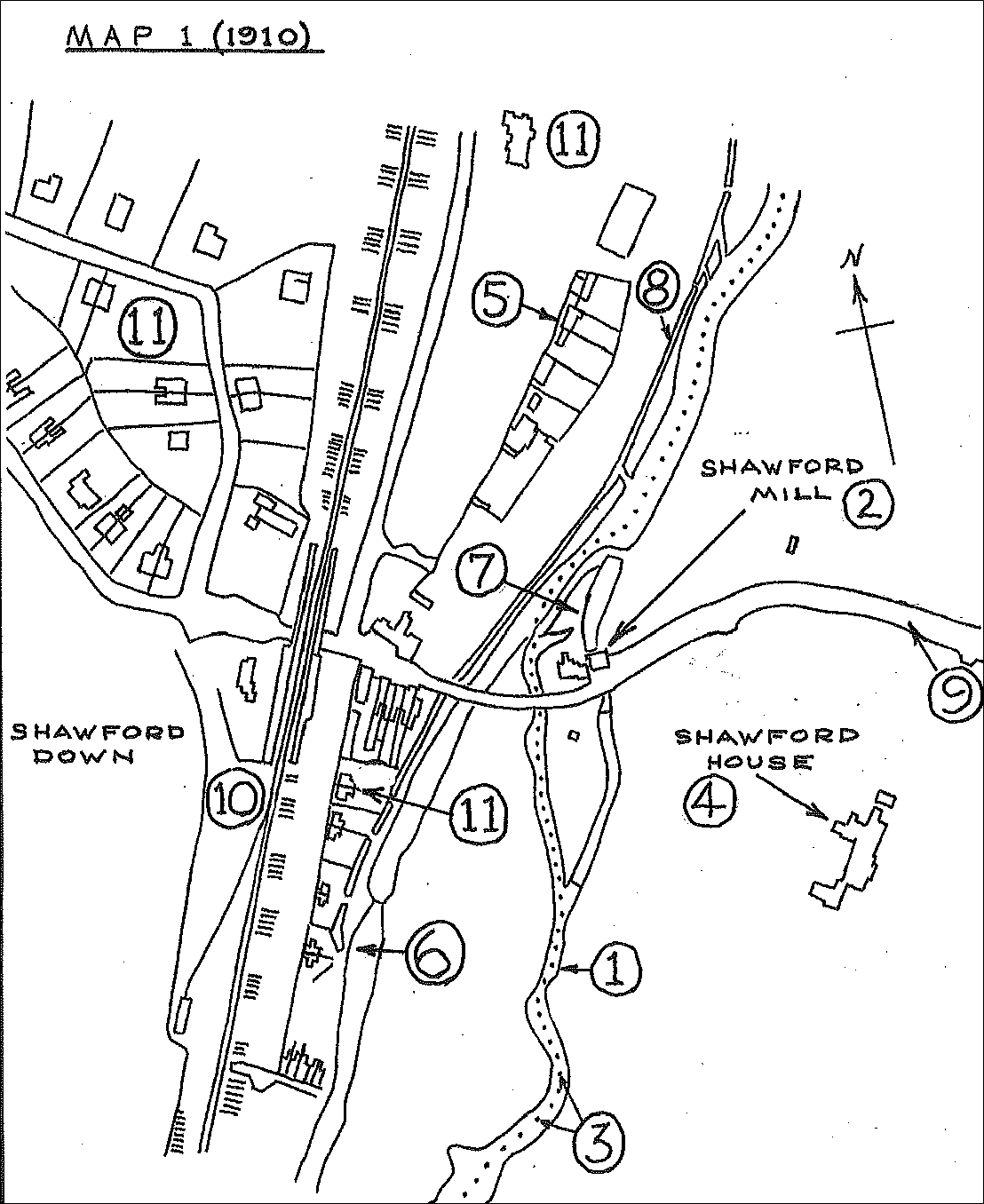
The numbers on Map 1 are roughly in chronological
sequence:
1. The Bishops Drain and mill leat...pre 1086 (see
note 2)
2. The mill…pre 1086.
3. The parish Boundary …pre 1086
4 Shawford house ….re-built about 1685
5. Group of older Shawford houses…. 1600’s and later
6. Itchen Navigation …about 1710
7 Shawford Mill wharf….about 1710
8. Goldfinches new drain (wrongly called Bishops
Drain)... 1810
9. Shawford Road realigned …1810 ?
10. Railway and accommodation works …1840
11.Shawford houses…1860’s to 1900’s
Clue 4: Documentary Evidence: Domesday and the Pipe
Rolls
The Domesday Book records Twyford as having six
mills, four within the main manor and two in a
second manor; none are named or located.
The Pipe Rolls of 1300/01 and of 1409/10 (HRO ed.
Mark Page) record Twyford as having five and four
mills respectively and both identify Shawford as the
location of a mill.
Clue 5:
The Ford over the Shawford Road
Now we turn to the Shawford Road. The crossing of
the valley from Twyford to Shawford is, I think, the
oldest and most used of all the routes across the
Itchen. Its approaches from both east and west are
much gentler than Winchester and the valley floor
much firmer; it is likely to predate the mill by a
millennium or three. Its course across the valley
makes use of the island of firmer ground in the
centre of the valley floor; most of this appears to
be gravel, with perhaps softer ground on the
Shawford side.
At this time, before the mill, the flow would only
have come from spring lines along the Western edge
of the valley along the boggy line at the bottom of
the Station Lane gardens; it would have flowed as a
winter bourne. So a short causeway would have
sufficed for the crossing of any soft ground.
However once the mill and its feed was built, the
flow of water across the Shawford Road was
increased to, - tradition has it, - about 1/3 of the
flow of the river, so forming a broad area of
shallow water, later known as Shawford Lake; this
name occurs in deeds and is still known of by local
residents.
I would guess that it went from the Mill race across
to the Navigation and perhaps 200 yards south. It
would have been fed both by the Mill race and by the
by pass channel
The approach to the ford of Shawford Lake from the
east was very gentle but from the west had a much
steeper gradient. It would have functioned as a
watering place for the animals grazing the down land
to the west.
On the 1:2500 OS maps of the 1930s, you can see how
all the tracks across Shawford Down converge on what
are now the Station and Down car parks.